Property Record
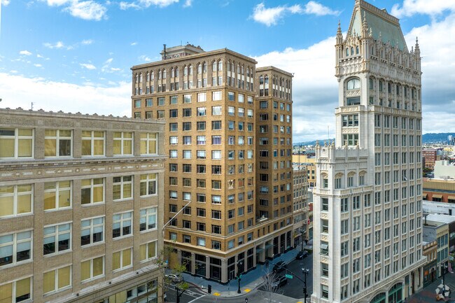
1611 Telegraph Ave, Oakland, CA 94612


Current Lease Availabilities
NEARBY LISTINGS FOR SALE OR LEASE
Property Detail
1611 Telegraph Ave
Oakland-Hayward-Berkeley, CA
G C Potter
008-0620-005-00
LOT: 00005 BLK: AR: 0008 PAGE: 0620
Officebuilding
Alameda
X
California
06001C0067H
1-4
2024
0.24 AC
2025
Oakland-Downtown
402801
East Bay/Oakland
121,676 SF
DEMOGRAPHICS near 1611 Telegraph Ave
1 Mile
3 Mile
5 Mile
2024 Total Population
54,484
267,275
505,410
2029 Population
53,832
260,776
491,346
Pop Growth 2024-2029
(1.20%)
(2.43%)
(2.78%)
Average Age
43
41
40
2024 Total Households
27,323
115,644
203,430
HH Growth 2024-2029
(1.16%)
(2.48%)
(2.84%)
Median Household Inc
$76,824
$93,942
$95,397
Avg Household Size
1.80
2.10
2.30
2024 Avg HH Vehicles
1.00
1.00
1.00
Median Home Value
$780,735
$1,005,601
$1,029,403
Median Year Built
1974
1958
1955
Nearby Places
Map Layers
Map Styles
 Street
 Aerial
- Restaurants
- Banks
- Shops
- Fitness
- Groceries
PUBLIC TRANSPORTATION
COMMUTER RAIL
DRIVE
WALK
Distance
5 min
1.7 mi
DRIVE
WALK
Distance
8 min
3.1 mi
AIRPORT
Metro Oakland International
DRIVE
WALK
Distance
Metro Oakland International
17 min
10.2 mi
San Francisco International
DRIVE
WALK
Distance
San Francisco International
36 min
22.0 mi
Norman Y Mineta San Jose International
DRIVE
WALK
Distance
Norman Y Mineta San Jose International
53 min
41.6 mi
Freight Ports
Port of Oakland
DRIVE
WALK
Distance
Port of Oakland
4 min
1.3 mi
Nearby Properties
Address
Land Use
TOTAL SIZE
Lot Size
Zoning
Address
Land Use
TOTAL SIZE
Lot Size
Zoning
409,266 SF
1.76 AC
Address
Land Use
TOTAL SIZE
Lot Size
Zoning
1,028,501 SF
2.74 AC
Address
Land Use
TOTAL SIZE
Lot Size
Zoning
652,524 SF
1.38 AC
Address
Land Use
TOTAL SIZE
Lot Size
Zoning
617,980 SF
1.08 AC
Address
Land Use
TOTAL SIZE
Lot Size
Zoning
568,722 SF
0.99 AC
Address
Land Use
TOTAL SIZE
Lot Size
Zoning
767,791 SF
1.38 AC
Address
Land Use
TOTAL SIZE
Lot Size
Zoning
373,594 SF
16.16 AC
Address
Land Use
TOTAL SIZE
Lot Size
Zoning
488,781 SF
0.63 AC
Address
Land Use
TOTAL SIZE
Lot Size
Zoning
490,000 SF
1.44 AC
Address
Land Use
TOTAL SIZE
Lot Size
Zoning
432,352 SF
Address
Land Use
TOTAL SIZE
Lot Size
Zoning
525,866 SF
1.38 AC
Address
Land Use
TOTAL SIZE
Lot Size
Zoning
354,263 SF
4.06 AC
Address
Land Use
TOTAL SIZE
Lot Size
Zoning
358,014 SF
5.03 AC
Address
Land Use
TOTAL SIZE
Lot Size
Zoning
546,164 SF
6.02 AC
Address
Land Use
TOTAL SIZE
Lot Size
Zoning
328,427 SF
0.52 AC
Address
Land Use
TOTAL SIZE
Lot Size
Zoning
423,577 SF
1.04 AC
Address
Land Use
TOTAL SIZE
Lot Size
Zoning
405,462 SF
11.67 AC
Address
Land Use
TOTAL SIZE
Lot Size
Zoning
621,432 SF
1.31 AC
C
Address
Land Use
TOTAL SIZE
Lot Size
Zoning
288,796 SF
0.52 AC
Address
Land Use
TOTAL SIZE
Lot Size
Zoning
371,504 SF
4.08 AC
Address
Land Use
TOTAL SIZE
Lot Size
Zoning
788,983 SF
1.63 AC
Address
Land Use
TOTAL SIZE
Lot Size
Zoning
0.73 AC
Address
Land Use
TOTAL SIZE
Lot Size
Zoning
703,758 SF
3.44 AC
Address
Land Use
TOTAL SIZE
Lot Size
Zoning
371,322 SF
1.62 AC
Address
Land Use
TOTAL SIZE
Lot Size
Zoning
240,633 SF
1.59 AC
Address
Land Use
TOTAL SIZE
Lot Size
Zoning
350,741 SF
1.08 AC
Address
Land Use
TOTAL SIZE
Lot Size
Zoning
344,273 SF
0.51 AC
Address
Land Use
TOTAL SIZE
Lot Size
Zoning
273,623 SF
1.44 AC
Address
Land Use
TOTAL SIZE
Lot Size
Zoning
245,717 SF
0.65 AC
Address
Land Use
TOTAL SIZE
Lot Size
Zoning
303,063 SF
1.27 AC
The World's #1 Commercial Real Estate Marketplace
Connect with us
© 2026 CoStar Group
The information above has been obtained from sources believed reliable. While we do not doubt its accuracy we have not verified it and make no guarantee, warranty or representation about it. It is your responsibility to independently confirm its accuracy and completeness. Any projections, opinions, assumptions, or estimates used are for example only and do not represent the current or future performance of the property. The value of this transaction to you depends on tax and other factors which should be evaluated by your tax, financial, and legal advisors. You and your advisors should conduct a careful, independent investigation of the property to determine to your satisfaction the suitability of the property for your needs.